Thursday, July 4, 2013

Fourth of July

This has been an ideal holiday celebration--special events taking place in addition to business as usual; everything in town is open except the Post Office, banks and pharmacies.

We knew that the front lawn of Parry Lodge would be the best spot for viewing the parade so we went into town early for breakfast and got a good parking spot.  Wandering along the main street until the parade started, we met two friendly couples who retired to Kanab, one from California and the other from Jackson Hole, WY.

The parade was well-organized, started on time and lasted about 45 minutes. 

 'Anticipation'
(People reserve viewing spots by putting out their chairs on July 3.)
 
 The Bible School float
 
 A gaggle of Uncle Sams
 
 Honey's Supermarket's entry, a huge shopping cart


The wet finale, thanks to the Forest Service
 

The next event was a fair in the park.  Food vendors, crafters and various charities set up canopies along the sidewalk and kids scampered in the splash pad awaiting the start of games.  We made a quick circuit of the offerings and, not seeing anything we wanted to spend time on, headed for the grocery store.  Later there will be a dinner, music, fireworks and an outdoor movie.  But those of us who have to get up at 5 AM won't be able to attend...........

Wednesday, July 3, 2013

Heat Wave

July 1-3, 2013

Our days off for this week, Monday through Thursday, come during a heat wave scorching the Southwest.  Temperatures during the day are over 100* and in the high 60s at night; our air-conditioner runs constantly.

We tried a close-to-home hike on Monday to look for Indian ruins in one of Kanab Creek's side canyons.  Although we set out before 8 AM, the temperature shot up rapidly as the sun rose above the cliffs.  About two miles up the canyon, the faint intermittent track we followed disappeared.  Because continuing down into the wash looked as difficult and dangerous as scrambling to the rim, we turned around and trudged back in blazing sunlight.

A respite from the heat seemed in order for yesterday and we stuck to indoor destinations--the barber shop, the museum in Fredonia, the bookstore and Kanab's Heritage Museum. 

A few weeks ago Fred found handprints and sharpening grooves on the cliff above the RV park and he wanted to explore that area more thoroughly.  By 7:15 we were threading our way over rocks, around scrubby trees and along steep piles of scree, climbing about 150'.  The reward for our exertion was discovering many petroglyphs, a weathered date with initials and more sharpening grooves.


Friday, June 28, 2013

June 26th & June 27th

The remainder of Wednesday was spent in domestic chores--putting away the groceries, unpacking, washing clothes, cleaning out the Jeep, etc.  Thursday morning, while it was still cool, we hiked up the cliff sheltering our little cove, which we've nicknamed 'Morris Mesa.'  It doesn't look that high from the RV park but gazing down from almost-the-top, we realized how far we'd ascended.  No discoveries of dinosaur tracks, Indian artifacts or rare wildflowers but we did get stunning views of Kanab to the south and Zion's white sandstone cliffs to the north.  And it also satisfied our curiosity as to 'what's up there?'.


From Morris Mesa,  Kanab to the south


 and Zion to the north.
 

In the afternoon, Fred worked out at the fitness center and Jan explored some of the shops before we had to attend a meeting of front desk staff at the lodge.  When we returned to the RV, it was suffocatingly hot, well beyond the ability of the A/C unit to cool even slightly.   With no shade at our site and temps of over 100* forecast for the next four days, we had to do something.  So we retracted the dinette slide on the passenger side to reduce the square-footage and eliminate windows on the east and west ends of the extension as well as the sky-lights in the ceiling.  We used sunshades from the 'eliminated' windows to insulate the rear and side windows in the bedroom.   Extending the awning and turning on a small fan each helped a bit.

After dinner we drove back to town for a talk at the BLM visitor center about the Spanish Trail.  In 1829 Armijo, attempting to establish a lucrative route between New Mexico and California, led 60 men and 100 mules across the seemingly impassable (and impossible) Cockscomb.  His plan was to trade New Mexican blankets and rugs for highly valued California mules and horses.  Recording only the briefest and sketchiest notes of his journey, Armijo's exact route is still to be determined.  A passage through the Cockscomb, perhaps near Armijo's, was used in the filming of the 1951 movie "Westward the Women."  The primary researcher mentioned that the actors and crew stayed at Parry Lodge and were bussed 65 miles to and from the shooting location each day.  The program was interesting and the presentation was effective and engaging.  It certainly deserved a larger audience than the seven us who attended.

Wednesday, June 26, 2013

Hurricane Hikes

Monday, June 25th
Day Off #1

In researching the area around Hurricane, UT we found references to Gould's Wash and Gould's Rim trails, both enthusiastically endorsed by mountain bikers.  We decided to hike part of the rim trail and evaluate it for ourselves.  Although the area was dry and desolate, the rim proved an interesting route with stunning vistas, unusual rock formations and little elevation change.  No shade and temps in the 90s led us to conclude this would definitely be more enjoyable in October than late June.  Getting back to the Jeep required battling a very strong headwind and took much longer than the out-bound trip.  Hot and dry and dusty, we headed for nice, long showers at the motel.


Gould's Rim Trailhead with
Pine Valley Mountains in background


Peaks of Zion peeking above the mesa


Tuesday, June 27th
Day Off #2

Back to Hurricane Hills to hike the Hurricane Canal trail that we had done in January, 2012.  In the past 18 months, some trail work and some new rockfalls had taken place but the long, steep descent from rim to river hadn't gotten any shorter or easier.  When we'd traveled about half way down, Fred realized he had left the GPS on the Jeep to acquire satellite signals.  He climbed to the top, retrieved the device, returned to me and we resumed.

 
Hurricane Canal Trailhead


Fred descending
 

When we reached the first rockfall, one we encountered in 2012, Fred was in the lead--until he stopped abruptly and stage-whispered, "Rattlesnake!"  Mr. Rattler, basking in the sun outside his den, had chosen a very narrow, no-other-options point in the trail for sunbathing. Our presence didn't inspire him to move so Fred tried tapping a on the ground with a long stick.  That must have irritated him because he rattled fiercely as he ducked under a rock uncomfortably close to the trail.  We gave him the widest berth possible and left the stick as a reminder to watch for snakes at that point on the way back.
Utah Midget Faded Rattlesnake

By-passing the next major rockfall requires descending from the canal, walking along a rudimentary road then scrambling over loose scree up to the canal.  We knew from prior experience that the collapsed tunnel which forces hikers to turn around  was only about 1/3 mile farther on.  So we opted to stay on the road, enjoy views of the Virgin River and look for a good spot for lunch.
 
 
Twin Falls
 

The hill down to the twin waterfalls was too steep but that shady place by the water a little further on was perfect.  Except it was on the far side of the river.  After twenty minutes trying to place enough rocks to hop across, we removed our shoes and waded.  We had left our shoes on the near bank so we weren't equipped to investigate the fossil-laden boulders nearby.


Fred on the trail, atop the outer wall of canal; canal is to his right
 

Walking back toward the trailhead was uneventful until we reached our rattlesnake-alert stick.  There he was--again!--smack-dab in the center of the space we had to cross.  He gave us a malicious rattle and slithered into his den, continuing the warning to keep our distance.

On the surface, back to the trailhead, Fred saw a lizard with unusual coloration standing on his rear legs with his front legs braced on a vertical rock.  He was nice enough to pose for several pictures, which let us identify him as a Black-Collared Lizard.


After cleaning up and cooling down, we went to the St. George BLM office to find out about some petroglyph sites we'd heard about.  Even though we didn't get the information we wanted, we enjoyed talking with the volunteer.  She and her husband had moved to SunRiver from Charlotte, NC in May, 2012 so we had lots of questions about their reasons, experiences and satisfaction. 

We finished the day with dinner salads and hot fudge sundaes at McDonald's and a little TV before lights-out at 10.  This morning was a stock-up trip at WalMart and back to Kanab.

Thursday, June 20, 2013

Dinosaur Tracks and Native American Handprints

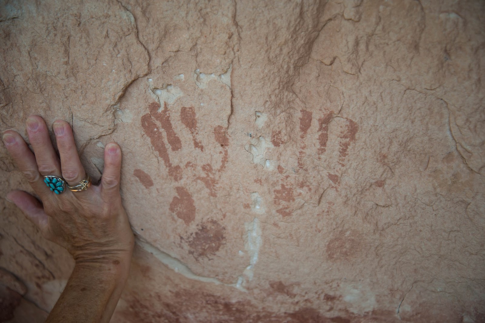
We are fortunate to be living in an area where dinosaur tracks, Native American artifacts and pictographs can be found with a 10 minute hike from our RV.  Below are pictures of three dinosaur tracks we found on a rocky ledge above the RV site and what may be Native American handprints on a cliff wall nearby.

 
Three-toed dino track
 

 Another track (?)
 
Track #3 (found 6/27)
 

Hand Prints on Cliff Wall 
 
 Tool Sharpening Marks in Cliff Wall
 
Plants are blooming in the desert garden next to our RV!
 

Teddybear Cholla


Cholla blossom
 
 
Things with thorns seem to do especially well here.

Wednesday, June 19, 2013

Better than Expected

Wednesday, June 19th
Day Off #3

I'd wanted to visit the Bingham Gallery, which showcases the work of Maynard Dixon,
ever since reading about it several years ago.   We had intended to stop Monday on the way to Escalante but missed the sign.  Canceling the Phipps Arch hike cleared our agenda for today, so we made the gallery our destination. 

What fortunate timing! We arrived a few minutes after 10:00, just as the owner was  unlocking the doors.  He told us the docent-led tour requires a reservation but the self-guided tour doesn't and Mrs. Bingham, at the house preparing for a day-camp group, could answer our questions.  The house is a small, simple, straight-forward cabin set in a shaded cove well-watered by an irrigation ditch with a spectacular view of southern Utah's iconic cliffs.                


Dixon's Thunderbird insignia above door to his studio
 

We encountered Mrs. Bingham inside the cabin and talked with her for 20 or 30 minutes.  She told us much of what you'd learn in the guided tour as well as how they came to own the property.  After working for Xerox in California during the dot.com era, they became art dealers specializing in works by Dixon and his contemporaries. 


'The Navajo'

They bought the home, studio and additional acreage following the death of Milford Zornes, a watercolor artist, who purchased it from Dixon's widow.   In 1999 they created the non-profit Thunderbird Foundation to preserve and maintain the property as a living history museum.

 
Dixon requested that his ashes be brought to Mt. Carmel.
They are buried beneath this boulder.

Touched and impressed by what we'd seen, we returned to the gallery and offered to take brochures and a poster to display at Parry Lodge.  Mr. Bingham told us about the collection of John K. Hillers* photographs they had purchased in the late 1990's  and showed us several of his portraits of Native Americans.  The collection will be sold at auction in the near future and the Binghams desperately want it to remain in this area.  In addition to the advertising materials, he sent us home with eight of Hillers' Native American prints and a book about Hillers' experiences traveling in the Southwest.

*Hillers served as the photographer for John Wesley Powell's second expedition (1872)down the Colorado River and for the Bureau of American Ethnology.


'Indian Boy and His Dog'
 

All that culture made us quite hungry so we stopped at the Thunderbird Restaurant for lunch and their Ho-Made Pie.

 
Fred, the Ho and the Pie


Memory Lane, Part Deux

Monday & Tuesday, June 17th & 18th
Days Off #1 & #2

Four days off!!  What a perfect opportunity to hike out of Escalante--slot canyons on Tuesday and Phipps Arch on Wednesday.


When Fred is charged up to go hiking, we mean that literally.
 

En route, we drove around Tropic and reminisced about our summer there two years ago.  We stopped at the visitor center in Escalante to ask about the condition of Hole-in-the-Rock Road (good) and the slots (dry) then checked into the motel, bought Fred a sun hat and had dinner. 

A good night's sleep and an early start saw us bouncing down Hole-in-the-Rock at 6:45.  By the time we began the descent into Dry Fork, the sun had already heated up its rock walls and sandy bottom.   The entrance to Peek-a-Boo looked dark, cool and inviting.   We scrambled up the 16-foot wall and into the bowels of the canyon.  Working our way along the narrow space required sliding, slithering and scooting as well as climbing and crawling but seeing the incredible forms and colors inside was well worth the scrapes and scratches.  When we were ready to leave, a family group appeared below.  We waited while they entered, with the assistance of an inadequate-looking rope for the older folks, then they waited to make sure we descended without incident.

 
Fred ascending entry to Peek-a-Boo
 

Jan's turn
 

Ta...
 

Dah!!


Inside Peek-a-Boo


Spooky, shorter, narrower and cooler than Peek-a-Boo, is about half a mile further down the wash.  On our previous attempt, I did about half its length when claustrophobia struck; this time, I was able to make it to where the 'slot' became a 'slit.'
Both of us had to remove our packs and Fred crawled through some of the tightest places.
 
 
Inside Spooky
 
 
Squeezing through Spooky
 
Fred has posted a GoPro video of the trip thru Spooky at  http://youtu.be/VGQHozLJuSU


From Spooky to Brimstone is a two-mile slog through deep sand alleviated by short stretch where the walls of Dry Fork are only about eight feet apart, providing a brief respite from the sun.  When we spotted a thin shadow at the base of a cliff, we realized we needed shade, rest and food.  After "a private moment with Mother Nature, " I sat down next to Fred then quickly sprang to my feet in pain.  Lots of shorts have a fly in the front; mine had a fly--the biting kind--in the seat!  Some rapid disrobing released it and saved me. 
 
 
Huge chockstones in narrow section of Dry Fork
 

The description of Brimstone as 'spookier than Spooky' is spot-on.  The rock walls are much darker, more convoluted and closer to each other so less light enters from above.
Again we had to take off our packs and slide sideways through some sections.  The deeper into the canyon we went, the more the temperature dropped until we eventually felt chilly.  In a wide space about halfway down, we met a group of teen-aged boys (scouts?) and their chaperones on their way out.  One of the leaders warned us that the way becomes 'pinchy' and reaching the end requires stemming.  We had no intention or desire to travel that far and turned around about half a mile from the entrance.


Interior of Brimstone


Inhale!


The BLM guide mentioned, but did not detail, a cross-country route back to the parking lot.  We found the trail and followed it, growing increasingly apprehensive about where it might take us.  We were relieved when it led us back into Dry Fork at the place where one turns toward Spooky.  Whew! we knew where we were and how to reach the Jeep.  But we also knew we faced a long, difficult walk through deep, powdery sand with full sun and a headwind.  Occasionally we encountered a bit of shade, some solid ground or a decrease in the wind; then the hike seemed momentarily more pleasant.

We reached the parking lot about 2:00 and skittered back Hole-in-the-Rock to Escalante,  the in-bound trip being much rougher than the out-bound.  Dinner the previous night had been too much and too heavy so we nuked frozen entrees from the grocery store in the motel room microwave.  During the evening, we assessed the toll the hike had taken--hours in the sun had worn us out and the sand in our shoes had abraded our feet--and decided to reschedule Phipps Arch for later in the season.